Introduction to Infrared Drones in Emergency Management
In recent times, infrared or thermal drones have become instrumental in managing disasters and emergencies. Their ability to capture and analyze thermal data has revolutionized search and rescue operations, firefighting, and environmental monitoring.
What Are Infrared Drones?
Infrared drones are equipped with thermal cameras that can detect heat signatures from various objects and living beings. These drones capture infrared radiation emitted by objects, which is then focused onto a detector array made up of microbolometers.
Each microbolometer converts the temperature data into an electrical signal, culminating in a visible image that represents different temperature ranges with varying colors.
Advanced Infrared Drones
DJI Matrice 350
Dimensions and Weight: The DJI Matrice 350 unfolds to 810×670×430 mm and folds down to 430×420×430 mm. Without batteries, it weighs approximately 3.77 kg and around 6.47 kg with two TB65 batteries.
Performance: It has a maximum takeoff weight of 9.2 kg, and its single gimbal damper can handle a payload of up to 960 g.
Operating Frequencies and Transmission Power: It operates between 2.4000-2.4835 GHz, 5.150-5.250 GHz, and 5.725-5.850 GHz, with varying transmission power across these ranges.
Hovering Accuracy and RTK Positioning: The drone's hovering accuracy is impressive, especially with RTK positioning, offering vertical and horizontal accuracies of ±0.1 m. RTK Positioning Accuracy reaches 1 cm + 1 ppm horizontally and 1.5 cm + 1 ppm vertically.
Speed and Altitude Capabilities: It can ascend at 6 m/s and descend at 5 m/s, with a maximum horizontal speed of 23 m/s. The maximum flight altitude is between 5000 m and 7000 m depending on the propellers used.
Wind Resistance and Flight Time: The Matrice 350 can resist wind speeds up to 12 m/s and offers a maximum flight time of 55 minutes under optimal conditions.
Gimbal and Payload Support: It supports various DJI gimbals and only certified third-party payloads developed based on the DJI Payload SDK.
Other Features: It has an IP55 ingress protection rating, supports multiple global navigation satellite systems, and operates in temperatures ranging from -20° to 50° C.
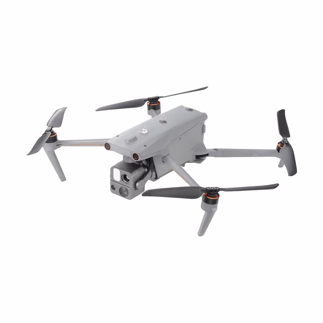
Autel EVO Max 4T
Size, Weight, and Design: The EVO Max 4T weighs 3.57 lbs with battery and gimbal and has a maximum takeoff weight of 4.41 lbs. Its dimensions vary based on its folded or unfolded state.
Flight and Performance: It has a maximum ascent speed of 8 m/s and a descent speed of 6 m/s, with a maximum horizontal speed of 23 m/s. The maximum takeoff altitude is 13,124 ft, and it can fly for up to 42 minutes in windless conditions.
Hovering and Navigation: Its hovering accuracy varies based on whether vision, GNSS, or RTK systems are enabled. It also boasts a comprehensive navigation system including GPS, Galileo, BeiDou, and GLONASS.
Camera and Imaging Capabilities: The drone features a 1/2" CMOS sensor for effective pixels of 48M, and a separate 1/1.28 CMOS sensor for 50M effective pixels, offering high-resolution photo and video capabilities.
Thermal Imaging and Sensitivity: The thermal imager is an uncooled VOx Microbolometer with a temperature measurement range of -4℉ to 302℉ and -40°C to 150°C.
Additional Features: The drone has indoor and outdoor non-GPS hovering capabilities, automatic obstacle rerouting, and can recognize and track multiple targets.
Parrot ANAFI USA
Physical Attributes: The ANAFI USA has a compact size when folded and a lightweight design at 500 g. Its maximum takeoff mass is 644 g.
Flight Specifications: It can fly for a maximum of 32 minutes, with a maximum horizontal speed of 14.7 m/s and wind resistance of the same value. The service ceiling is 5,000 m above mean sea level.
Sensors and Navigation: The drone is equipped with GPS, GLONASS, and Galileo for navigation, along with a barometer, magnetometer, vertical camera, and ultra-sonar.
Imaging Technologies: It includes a digital zoom of 32x, with video resolutions up to 4K and photo resolutions up to 21 MP. The EO image chain offers a wide field of view and supports both JPEG and RAW formats.
Infrared Imaging: The IR image chain is powered by a FLIR BOSON sensor, offering a thermal sensitivity of ≤60 mK and a temperature range of -40°C to +150°C.
Stabilization and Control: The drone features a 3-camera IR/EO stabilized gimbal with a controllable tilt range of -90° to +90°.
These advanced infrared drones, with their specific features and capabilities, are well-suited for a variety of applications including disaster response, environmental monitoring, surveillance, and more.
Advantages in Disaster Scenarios
Quick Deployment and Wide Coverage: Infrared drones can be rapidly deployed to disaster sites, offering a broad aerial view that is crucial for quick assessment and planning of rescue operations.
Access to Dangerous or Inaccessible Areas: These drones can access hazardous areas without risking human lives, such as regions with chemical spills, high radiation levels, or unstable structures.
Real-Time Data for Decision Making: The immediate data provided by these drones assists in making informed decisions, crucial during the golden hours of rescue operations.
Night-Time Operation Capabilities: Their ability to detect heat signatures makes them effective for night-time operations, a critical factor in continuous rescue missions.
Enhancements and Potential
The future of infrared drones in disaster response is promising. Anticipated advancements include improved battery life for longer flights, enhanced camera resolution for finer detail, and AI integration for smarter data analysis. These enhancements will further empower emergency response teams to act swiftly and effectively, potentially saving more lives and mitigating disaster impacts.
Infrared drones have become indispensable in modern disaster response strategies. Their advanced thermal imaging capabilities, coupled with increasing technological enhancements, are setting new standards in emergency management. As this technology evolves, it promises to further transform the landscape of disaster response, making it safer, more efficient, and more effective.
FAQs for Infrared Drones in Disaster Response
What makes infrared drones essential in disaster response scenarios?
Infrared drones are crucial due to their ability to quickly assess disaster sites, access inaccessible areas safely, and provide real-time thermal data for effective decision-making.
How do infrared drones assist in firefighting?
In firefighting, infrared drones identify hotspots and monitor the spread of fires, especially in areas with dense smoke or limited visibility, thereby aiding in strategic firefighting and evacuation planning.
Can infrared drones be used at night?
Yes, infrared drones are highly effective at night because they detect heat signatures rather than relying on visible light, making them invaluable for continuous rescue operations.
What advancements are expected in infrared drone technology?
Future advancements include longer battery life for extended flight time, higher camera resolution for detailed imaging, and AI integration for smarter data analysis and automated operations.
Are infrared drones safe for use in hazardous areas?
Infrared drones are ideal for hazardous areas as they can safely navigate through environments with high radiation, chemical spills, or unstable structures without risking human lives.
By clicking “Accept All Cookies”, you agree to the storing of cookies on your device to enhance site navigation, analyze site usage, and assist in our marketing efforts. View our Privacy Policy for more information.


.jpg)